Collaborative Project »EULIAA«

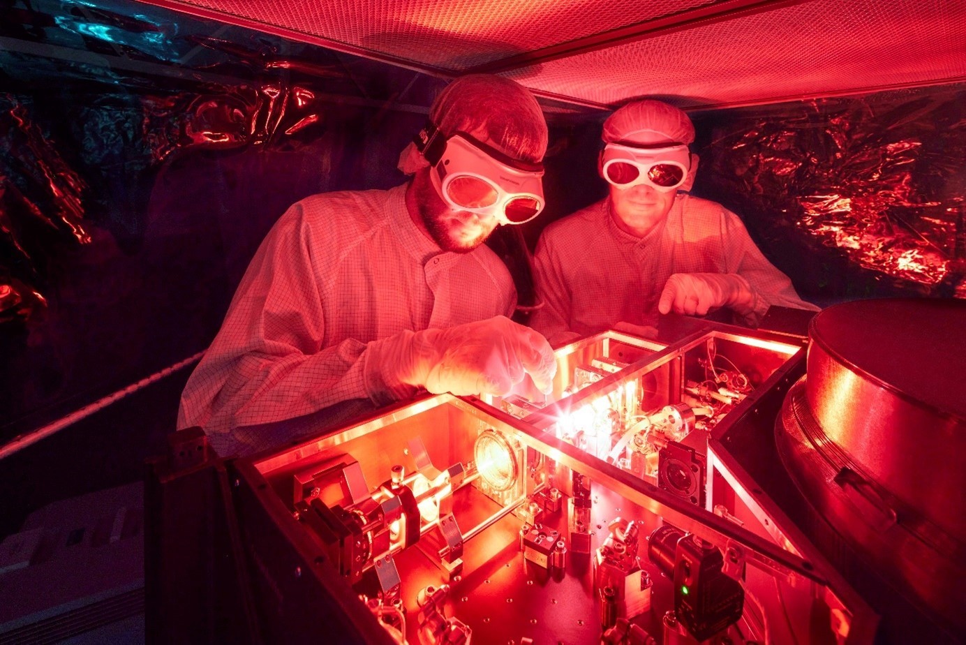
EULIAA - European Lidar Array for Atmospheric Climate Monitoring

© Fraunhofer ILT, Aachen.

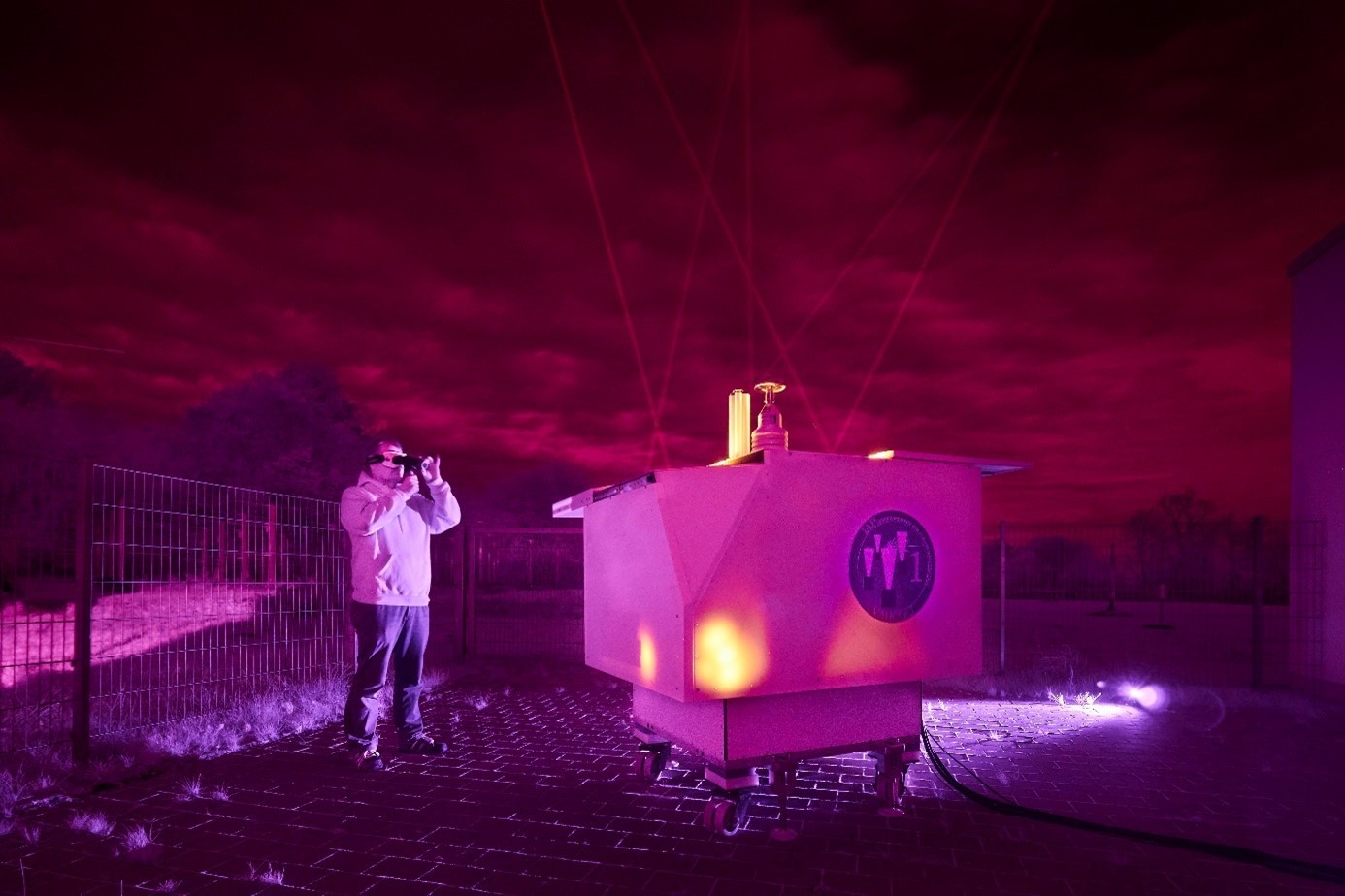
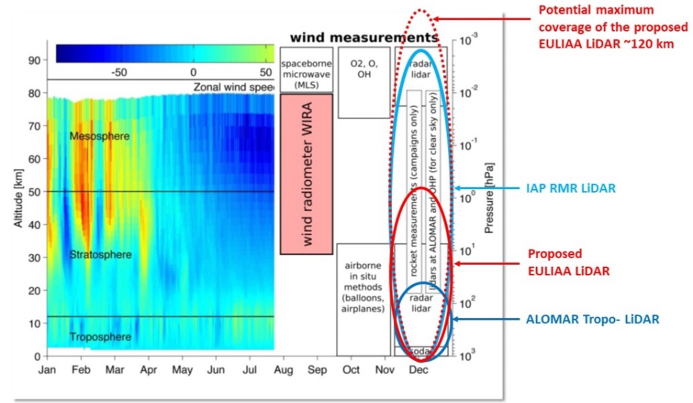
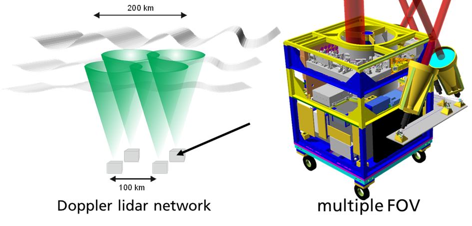
Efforts to mitigate climate change have made understanding and monitoring atmospheric physics (including wind and temperature distributions in the atmosphere) increasingly important. It is crucial to improve climate models and weather forecasts. However, there is a data gap for continuous measurements above 5 km, which is the maximum height of commercial compact wind radars and lidars. The EU-funded EULIAA project will develop a lidar array measuring autonomously the atmospheric wind and temperature from 5 km up to 50 km on a 24/7 basis over a long period (more than 1 year without maintenance) and covering a large observation area (up to 10 000 km2). The new lidar units are low priced, compact, efficient, easily transportable, and powered by wind turbines or solar panels.

EULIAA will yield novel data sets in near real-time for implementation into European databases Copernicus and GEOSS, that will fill current data-gaps and help to monitor the effects of climate change and to evaluate climate protection measures.

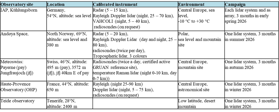
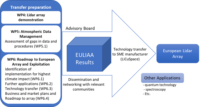
Once the enhanced capability developed within EULIAA has been demonstrated and validated in difficult-to-reach regions (polar, equatorial, and mountain), with a high TRL (6–8), a business plan and roadmap for a European array will be produced, involving relevant industrial, standardisation, and end-user actors.

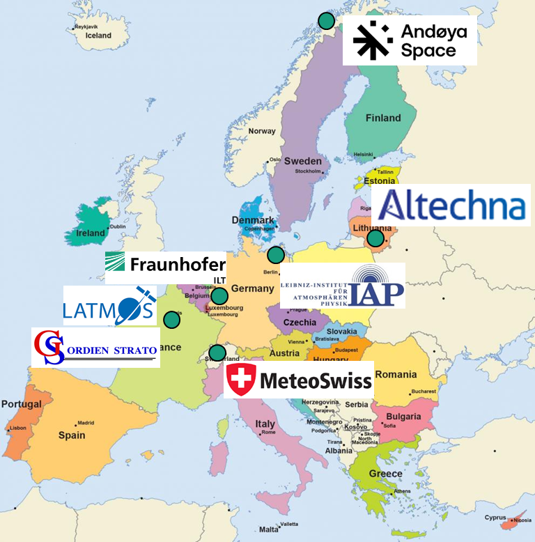
The EULIAA project (lasting 48 months and budget of 3.2 M€) gathers 7 partners from 5 countries with experts in lidar and its subsystems, atmospheric observatories, and atmospheric data provider. It contains all the necessary disciplines to ensure the technological development, data transfer, and sustainable exploitation.

Objectives

© Leibniz Institute for Atmospheric Physics IAP

1. Superior daylight-capability of the novel lidar systems

To demonstrate the superior daylight-capability of the individual low-cost and compact lidar system by measuring key parameters for monitoring climate change, e.g. wind, temperature, and aerosols with simultaneous Doppler-Rayleigh and -Mie during daylight at altitudes from 5 to 50 km. The lidar will have best performance in the troposphere, but even the altitude above 20 km will be continuously monitored with high resolution (line of sight wind error < 1m/s, temperature error < 1 K, 200 m binning, 5 min measuring) and even the maximum measurement range (up to ~25 km) of the Gold-Standard data provided by AEOLUS will be doubled. The spatial and temporal resolution at 20 km altitude will be comparable to the largest scientific radar systems (about 6000 m²) in the world, but the highest altitude reached will be twice as high, being 20 times higher than that of state-of-the-art commercial lidars. The data-gap within this currently inaccessible region of the atmosphere is closed using a novel Doppler-lidar array with multiple fields of view (FOV).

© Leibniz Institute for Atmospheric Physics IAP


2. Demonstrate and validate the potential of a lidar array

The combination of two individual compact lidar systems with overlapping measurement regions as the first step to a lidar array that is able to cover a large area (> 100 km observation span) and provides five wind-components for each system. An initial European lidar array of 10 units will allow for the observation of gravity waves throughout the upper troposphere and stratosphere, deepening the understanding of global atmospheric energy transfer important for understanding climate change and improving weather prediction. The measurements are validated with well-established scientific infrastructure (lidars, radars, sounding balloons) at leading European atmospheric research facilities and datasets from European databases like ECMWF and Copernicus.

© Google Maps
© Fraunhofer ILT, Aachen.


3. Demonstrate performance in challenging environment all over europe

To prove the operation in areas facing extreme physical environments by performing measurements on at least four different sites with Polar (North Norway), Mountain (Swiss), Mediterranean (France) and near Equatorial (Tenerife) environments and from sea- to mountain-level. At each site, the gathered data is compared with the existing, elaborated, and calibrated measurement infrastructures, such as radars, lidars, and sounding balloons. The deployment to these sites demonstrates the easy deployment due to the compact design (~ 1m3), the low weight (~500 kg), and the autonomous 24/7-operation. The low power consumption (~500 W) allows the use of off-grid power sources such as small mobile wind turbines, solar panels, and fuel cells, and together with the maintenance-free operation, yields sustainable long-term observations. The experience with the operation of the lidar units allows for an assessment of the possibility of airborne operation of the lidar units with only slight adaptations.

4. Filling the gaps by integrating the data in European databases

To add value to environmental observation not only by gathering data to fill the gap for continuous atmospheric key parameters > 10 km (see objective 1), but also by integrating them in near-real-time into European databases like Copernicus, making them available for the scientific community and the general public, while promoting the technology with the same measure and making it available to industry by the end of the project. This supports the goal of the Green Deal to develop a high precision digital model of the Earth, including the whole atmosphere, to boost the EU’s ability to predict and manage environmental changes.

© Fraunhofer ILT, Aachen.


5. Roadmap to a European lidar array for atmospheric climate monitoring

To ensure the sustainability of technological development by elaborating a roadmap to a European lidar array for atmospheric climate monitoring. EULIAA will assess the TRL status of all specific components, identify industrial partners for exploitation, and define the necessary next development steps. Together with industrial partners to whom the technology of the lidar operating in the IR is currently transferred, the necessary adaptations and additional transfers for the next generation operating in the UV and with multiple FOV will be assessed. Further applications like the deployment of calibration and validation of future spaceborne EO missions will be discussed with the identified stakeholders.

News

This year we started our new EU-funded project EULIAA: European Lidar Array for Atmospheric Climate Monitoring with our hybrid kickoff-meeting online and in Aachen.

Within the project the partners Fraunhofer Institute for Laser Technology (ILT), Leibniz-Institut für Atmosphärenphysik (IAP)AltechnaAndøya SpaceBundesamt für Meteorologie und Klimatologie MeteoSchweizLATMOS Laboratoire Atmosphères, Observations Spatiales and GordienStrato will develop novel mobile ground-based lidar systems that can operate in an array over large areas, demonstrate the performance in extensive field campaigns all over Europe and feed the atmospheric data in near real-time in the European database like COPERNICUS and GEOSS.

We are a great consortium with many experts in all the relevant fields and eager to approach the challenge of such an ambitious technology. We are thankful to the European Commission for their trust in us and the opportunity to push the development for closing gaps in environmental data to monitor climate change.

We will keep you updated about our mission, consortium, achievements and possibilities to meet us and be part of our development. If you like, also follow us on LinkedIn EULIAA.

© Fraunhofer ILT, Aachen.

The partners

Within EULIAA seven partners, research organizations and SMEs, from five countries all over Europe bring together their unique expertise in atmospheric measurement, lidars, lasers, optics, and data management to develop the European Lidar Array for Atmospheric Climate Monitoring.

© europa.eu

Fraunhofer Society for the Promotion of Applied Research

The Fraunhofer Society for the Promotion of Applied Research e.V. is a link between science and industry, that is between the research and the application of its results. It has 12500 employees in 56 Institutes at 40 locations and a research budget of about 1.2bn €. With more than 250 employees and 10,000m² of usable floor space the Fraunhofer Institute for Laser Technology ILT, is world-wide one of the most important development and contract research institutes in laser beam sources and components, the use of modern laser measurement and testing technology and laser-supported manufacturing. ILT has expertise in Optics design, Non linear optics, Tunable laser and packaging that will be relevant for EULIAA.

https://www.ilt.fraunhofer.de/

Leibniz Institute for Atmospheric Physics IAP

The Leibniz Institute for Atmospheric Physics IAP conducts research in physics of the mesosphere and lower thermosphere in close collaboration with national and international partners. IAP main research themes in the middle atmosphere (10-120 km) are the exploration of the atmosphere (temperature, wind, metal layers, aerosols, …); the coupling of atmospheric layers (tides, planetary waves, gravity waves and turbulence, …), the long-term changes (climate change, trends, …), the development of novel measurement techniques (lidar, radar, radiosondes, sounding rockets, …) and worldwide measurements with focus in mid-latitudes, the Arctic and Antarctica.

https://www.iap-kborn.de/

Altechna

Altechna provides dielectric coatings and optical designs for industrial customers to reconsider laser geometries and achieve even higher peak levels of power, or to reduce the weight of the final commercial products. From test batches to mass production, the quality and repeatability of each product are assured by a metrology laboratory. AC can provide innovative solutions from femtosecond to continuous-wave technology.

https://www.altechna.com/

Andøya Space

Andøya Space provides the services and technologies that enable the science communities to explore our atmosphere and space environment. Andøya Space allows end-to-end testing of sensor systems. Regarding the Andøya Space observatory aspects, it is designed to minimize the effects of wind to provide an optimum environment for the lidar instrumentation. The beams can reach over 100 kilometers, and some can be tilted several degrees.

https://www.andoyaspace.no/

Gordien Strato

Gordien Strato is a French company working in the following domains: Atmospheric lidar, High altitude atmospheric physics, Total ozone (O3) and NO2 observations. Gordien Strato has a background in lidar technology (Rayleigh, Backscatter, Raman and Doppler wind lidars) and UV-Visible spectrometers (Mini-SAOZ instrument) within the scientific community, having helped to bring the technology from academia into the marketplace.
The company built, upgrades and maintains one of the worldwide most powerful Rayleigh lidar (the mosaic of eight 50cm-diameter telescopes, and six 24W-lasers) for the measurement of atmospheric temperature and density up to 110 km height, on French Ship “BEM Monge”.
Gordien Strato implemented a new Hi-Performance multi-wavelength Raman Lidar for Cloud Aerosol Water Vapor Research (IPRAL) at SIRTA/IPSL. This high-power research Lidar includes innovative characteristics that do not yet exist among current lidars in France.

LATMOS

LATMOS is the Atmospheres, Space Observations Laboratory specialized in the study of the fundamental physico-chemical processes governing the terrestrial and planetary atmospheres and their interfaces with the surface, the ocean, and the interplanetary environment. LATMOS has developed strong instrumental skills, built innovative instruments deployed from the ground and sometimes put into orbit or set off to encounter other bodies in the solar system. Numerical atmospheric models are also developed and used to interpret the various observations.

https://www3.latmos.ipsl.fr/

MeteoSwiss

MeteoSwiss is a research entity participating in national and international collaborations with universities and other national meteorological services. MeteoSwiss focuses on applied research along with development of new production methods and new weather and climate products. MeteoSwiss works in close cooperation with universities and the research institutions of ETH Zurich to ensure the seamless transition from university research to internal applied research and development.

https://www.meteoswiss.admin.ch/about-us/research-and-cooperation.html

»EULIAA« is a joint project of Fraunhofer ILT with the following partners:

Leipniz Institute for Atmospheric Physics IAP


Latmos


Altechna


Andoya Space


Meteo Swiss


Gordien Strato